Rainwater to Wastewater
From the Harlem River to Flushing Bay, these stories explore the systems, histories, and choices that determine our access and use of the waterways.
Harlem Waterfront Woes
Bronx community organizers fight for improved waterfront access
Wandering for Water
The sun shines shyly through the haze on a mid-November afternoon in the Bronx. Swaddled in coats and scarves, community organizers from South Bronx Unite lead a tour through their neighborhood highlighting public greenspaces and inequities in waterfront access. At the penultimate stop on the walking tour, Matthew Shore and Kaila Paulino point to a luxury apartment building towering over the waterfront by Lincoln Avenue.
“This is simply development not done right, in our opinion,” Shore says.
The bankside development includes a greenspace with a winding footpath, concrete benches, and lawns punctuated with shrubs and yellowing trees weathering the fall. A sign at the entrance to the park reads “OPEN TO THE PUBLIC” but is caveated with rules of conduct explaining that “this is a privately owned space designated and intended for passive recreation.” Noted among these rules are prohibitions from biking or skating, feeding birds, and gatherings of more than 100 people.
Despite the growing daylight, the park is nearly empty, besides a couple walking their golden retriever on the far end of the pavement. As the tour group takes in their surroundings, Shore and Paulino explain that community members were not initially aware that this space even existed. Shore then relates an incident from a similar tour a while back, when a security guard insisted that large groups need to RSVP to access the property. In response to this incident, South Bronx Unite organized a rally to bring attention to community need for access to the waterfront.
The Bronx continues to have a critical lack of access to its waterfront. Despite its proximity to the East and Harlem Rivers, residents of the Bronx have few waterside parks and footpaths to actually be close to the water. For many, the closest waterfront access is Randall’s Island — which requires people to travel south over the RFK Bridge. The city is working on a walking and biking path near the south-western Bronx waterfront, but the project won’t be completed for years, and even then, will not exist directly adjacent to the water.
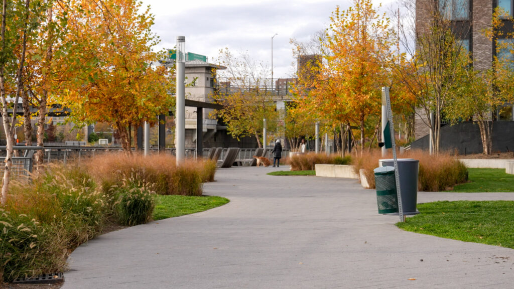
The public can access this privately owned waterfront park in the South Bronx.
The tour procession then walks five minutes away, through a fence gate, up a tarmac pavement pockmarked with weeds and over a commercial railway line, and gathers in a loose circle on an uneven slope descending into the river. To the left, a man angling for striped bass adjusts his fishing lines behind a row of concrete barricades wallpapered with graffiti.
On the right, a high wire fence partitions the launch from an unkempt lawn running parallel to Lincoln Avenue and the railroad leading east to a Waste Management facility and a Fresh Direct warehouse. As Shore and Paulino speak, their voices rise over a cacophony of heavy machinery and passing freight trucks.
“Make no mistake, this is public land,” Shore says. “And it is not being used for public good.”
The local community has been attempting to convert this disused area into a proper public greenspace for many years — invigorating this space is part of South Bronx Unite’s waterfront plan — but to no avail. The organization has, however, secured some funding to develop this area through the EPA Community Change Grant. In the meantime, the community often gathers on the grassy patch for barbecues and other celebrations.
“The expressions, the reactions, of families when they come to this space … it’s priceless,” Shore says. “People feel less stressed when they are next to the water’s edge, and there’s been studies that show that there are a lot of mental health benefits to being right here. … This is another space that can provide much needed, and much awaited, healing in the neighborhood.”
Safe Ways and Greenways
Father and daughter would bike down the Hudson River Greenway on her way to school every morning. They would start in the Highbridge neighborhood of the Bronx, cross the Macombs Dam Bridge and head west through city streets, and finally turn north up the paved bike trails of the Hudson River Greenway. Chauncy Young, a community organizer from the Bronx and founder of the Harlem River Working Group, says these morning bike rides with his daughter were formative in her life. She attended school on Dyckman Street, and biked six miles each way, everyday; Young simply wasn’t comfortable letting her make the journey alone. But once they reached the greenway, he felt safe.
“That’s the perspective of what a greenway does,” Young says. “It creates a safe space. And as they’re going back to the issue of health, we don’t have greenways to the extent that we have greenways in other parts of the city, something that we’ve been advocating for, for many, many years. Because the Bronx is 62 out of 62 counties in the state of New York in terms of health disparities.”
The Hudson River Greenway is a unique trail stretching 750 miles across New York State. Young’s daughter has actually biked all the way to Niagara Falls from their home in the Bronx. The idealism of this greenway is as much about safe pedestrian and bike travel as it is about waterfront access. The trail extends all the way along Manhattan’s western waterfront, connecting several parks and bike lanes to enable essential recreational facilities for local residents.
A few years ago, the New York Economic Development Corporation began work on the Manhattan Waterfront Greenway, which will eventually create a loop around the full perimeter of the island. This includes planned development along the Harlem shore to create new parks, green infrastructure for stormwater management, and an overall elevation to account for 2080 water level projections.
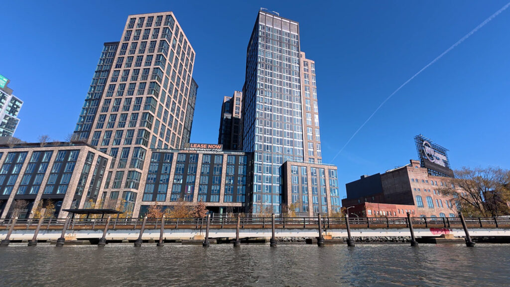
High end real estate, industrial development, warehouses, and railroads block large swaths of the waterfront.
In the meantime, the Bronx bank of the river continues to have limited public access to waterfront open spaces.
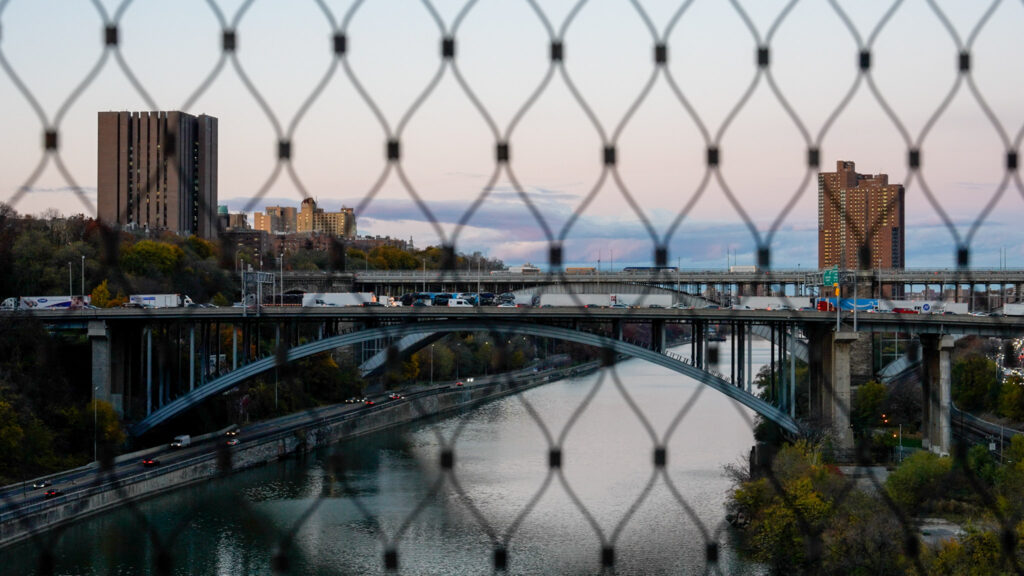
Looking out over the Highbridge, a pedestrian bridge connecting the Bronx and upper Manhattan, Young says transportation infrastructure built under Robert Moses’ direction disconnected local residents from their waterways. Where there were once boatyards and recreational launches, now sit train tracks and warehouses used by Metro-North and the Major Deegan Expressway.
“We prioritized roads over people’s connection to the waterfront,” Young says. “And as development happens, there was less thought of the river as a space that people would want to visit, and more thought of the river as an obstacle.
Earlier this year, the Department of Transportation began construction on a Harlem River Greenway in the Bronx, which will chart a seven-mile route south from Van Cortlandt Park to the river, strafe the water from a few blocks inland, and ford the East River into Randall’s Island. Christina Carrero, Urban Waters Ambassador for the Bronx and Harlem River at the Hudson River Foundation, says the bike path doesn’t reach the waterfront itself because of several reasons, but primarily land ownership challenges.
“The major goal from the community members is to have that waterfront greenway,” Carrero says, “because it provides recreational opportunities for community members, safe transportation, which is a major concern … in parts of the Harlem River watershed, particularly in the Bronx.”
The first piece of the project to be completed was a bike path over the Deegan Expressway and Metro-North tracks for cyclists in the Highbridge neighborhood to more easily access Bridge Park and Roberto Clemente State Park. By the end of the year, DOT promises to open several other protected bike lanes along the proposed greenway, while EDC and the city Parks & Recreation Department intend to open a 2.3-acre waterfront park called Lower Concourse Park.
Several government officials commented on the achievements and improvements to neighborhood infrastructure in a May press release on the Harlem River Greenway. Ydanis Rodriguez, the NYC DOT Commissioner, says these projects improve connection to the waterfront for Bronx residents and highlights the new bike routes.
“Each project reflects feedback we’ve received from residents at our workshops and we’re excited to get to work to start quickly building out the greenway, with more upgrades to come,” Rodriguez says.
DOT, EDC, and the Parks Department held community engagement and feedback sessions in anticipation of their final greenway plan. Young says the final proposal is the culmination of over three decades of community engagement and advocacy.
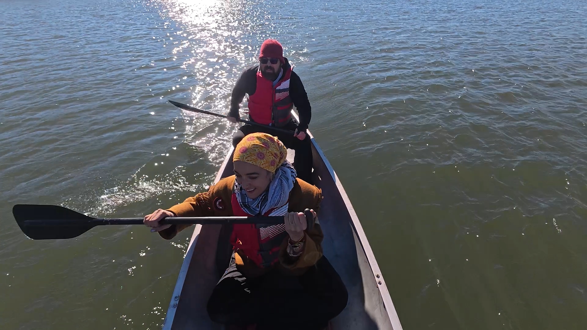
Paddling Together
Runoff from vehicular traffic on the many bridges over the Harlem River contribute to high levels of water pollution.
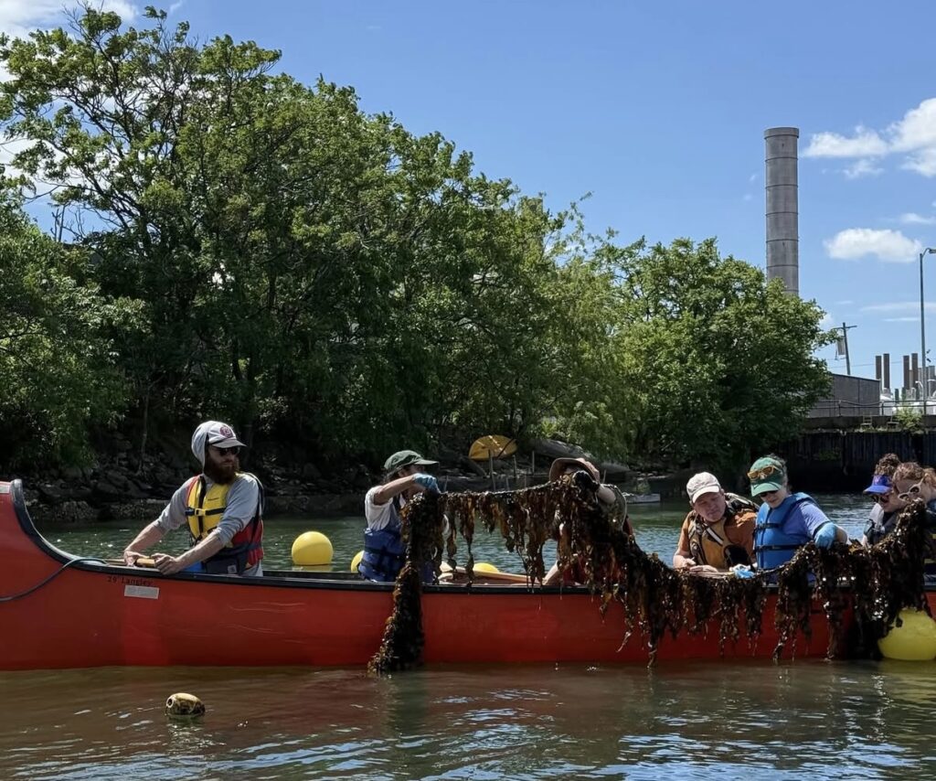
Every year, the nonprofit organization Wilderness Inquiry takes students on the Harlem River in a program called Canoemobile. Hundreds of schoolchildren board massive canoes in groups and row along the Harlem River — this is often the first time for many participants. Young works alongside Canoemobile organizers as they hoist canoes on their shoulders and march them from their storage depots to launch sites along the river. The sheer size of the canoes makes them nearly impossible to capsize, even with a crew of inexperienced kids.
“In the years we’ve done it, we have never flipped a canoe,” Young says. “They said that it happened once because they were doing it in a location where a fish jumped into the boat and all the kids got scared and leaned out totally to the one side.”
Flipping a recreational canoe in the Harlem River is far from fatal. Earlier this year, the state declared the river safe for swimming as long as rain hasn’t caused combined sewage overflows in the last 36 hours. This redesignation comes after years of industrial and municipal waste dumping into the Harlem River, which by all accounts left the river disproportionately polluted as compared to other waterways in the city.
A successful campaign for river health is the daylighting of Tibbet’s Brook. This inland waterway once flowed all the way into the city’s rivers, but was eventually routed underground and into the sewer system. After decades of advocacy and organizing by Young and others like him, a portion of the river will be brought back above ground, or daylighted. The project will mitigate the intensity and quantity of sewage overflows by reducing the existing amount of water flowing through the system.
While the water quality has improved over time, and is technically safe to swim now, it is not absolutely devoid of potentially harmful bacteria and waste particles. The risk in engaging in recreational opportunities on the river is finally a question of personal preference and comfort. Young wants to encourage people to avail river swimming opportunities by hosting large swimming events in the coming summers.
As organizers and government officials work together to pave a new future for waterfront access in the Bronx, Young highlights the importance of community engagement.
“The idea is that we want to have a united voice for the Harlem River,” he says. “But we also want to make sure that when we’re talking about topics like the daylighting of Tibbetts Brooks … the community members that live along that corridor should be the primary voices in that process.”
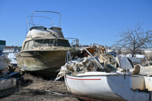
The Abandoned Boats of New York
How left behind vessels create a crisis on the water
Parts of microplastics, trash, and empty vessels lie scattered on a shore in College Point, Queens. A quiet, peaceful, and isolated coast is now facing a great risk of water pollution.
Hundreds of abandoned boats are in New York City’s waterways. They are found all over the waterway, from the Long Island Sound – historically known for its rich recreational purposes, marine mammals, and where fresh river water and Atlantic saltwater collide – to Jamaica Bay, the key habitat for shellfish, Flushing Bay, and College Point, Queens.
According to HYDR8, a Zero Waste Pantry organization, estimates around 18–21 billion gallons of untreated or partially treated sewage are dumped into the water within the five boroughs. Around 520 abandoned and neglected boats have added to the harmful chemicals, degrading the water quality of the city. Some were washed up by Hurricane Sandy, while several others have been forgotten on the shoreline, posing a great danger to the marine ecosystem.
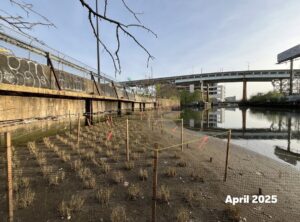
An abandoned boat sits on the shore of Hart Island in the Bronx, New York City, on April 17, 2025. Photo credit: NYC Parks / Daniel Avila
“We have always noticed abandoned vessels and rotting piers and pilings for many years,” said Kathryn Cervino, president of the Coastal Preservation Network.
“It’s really beyond the scope of what we, as well-intentioned volunteers, can really handle.”
Volunteers can only do so much since it can cost up to $7,000 to dismantle and dispose of a single boat. For boat owners, this cost leads some owners to walk away and strand their boats. The vessels are too large to move, too expensive to dispose of, and not easy for community members to remove.
This has become a significant threat; the process of decay happens when a wreck breaks down into the water over time, releasing debris and hazardous substances that start to harm the marine habitats. Leaked oil from the boat releases fiberglass fractures and microplastics that then add to the heavy pollution of the water.
Fiberglass creates pollution through the degraded parts of the boat, releasing particles that are then ingested by oysters and mussels, leading to sickness or death.
Leaked oil sheens from boats can suffocate organisms underwater. Heavy metals left on the seabed remain for years, leading to the poisoning of crabs and clams.
“Biologically, we’re seeing risks such as chemical poisoning and even cancer in marine life caused by petroleum VOCs and paint cans,” said Dr. James Cervino, marine and environmental specialist and vice president of the Coastal Preservation Network.
VOCs are volatile organic compounds found in petroleum and paint from the leaked substances of the vessels and debris. Many of the containers can hold unknown amounts of hazardous substances, impacting marine life and human health.
Vessels that rest directly on the sediment surface block the natural exchange between the sediment and surface waters, making it impossible for infauna to survive – an organism that is an essential food for fish and wading birds.
The Coastal Preservation Network was founded in 2002 by Kathryn Cervino and Dr. James Cervino as a way to help clean up the coastline by College Point, Queens. They have expanded into coastal restoration, planting seagrasses, doing oyster restoration, and advocating for public access for the community to not only look over a fence but be able to have access to the water and enjoy it.
The Coastal Preservation Network, as an established community partner on the ground, collaborated with the Chief of Waterfront and Marine Operations at the NYC Department of Parks & Recreation, Nate Grove and Marine Debris Disposal & Vessel Surrendering Coordinator Kathryn Stromme to proceed with this new abandoned vessel and marine debris removal program after receiving a federal grant of around $2,328,080.
“We also find that there is often a “clustering” effect where one or two abandoned boats in an area will invite more of the same, and an area can become seen as a dumping ground for unwanted vessels.” said Kathryn Stromme, Marine Debris Disposal & Vessel Surrendering Coordinator
In response, the city launched the Office of Marine Debris Disposal and Vessel Surrendering last spring as part of NYC Local Law 46 of 2023. This law requires the office to remove any kind of marine debris from the water in collaboration with cities and agencies; plan, develop and recycle debris and dispose of any substances that can’t be reused; and apply policies against residents who take part of the ongoing crisis; abandoning debris and vessels.
According to City Meetings NYC, with new funding for fleet maintenance and marine debris disposal, more than 82 vessels and 430 cubic yards of debris have been removed from the city’s waterways since 2024.
The areas being covered are Arverne and College Point in Queens, Westchester Creek in the Bronx, Flushing Bay, Four Sparrow Marsh, Marine Park, and Paerdegat Basin in Brooklyn, and the East River waterfront. Beginning in Spring 2026, the project will cover the disposal of 4,000 cubic yards of large marine debris. Additionally, the program will include training and engagements with volunteers for beach clean-ups in College Point and Jamaica Bay.
“A fiberglass boat is a motorized boat, so if you are abandoning a vessel, you have an engine, which means there is fluid to lubricate, there is oil, there is fuel,” Cervino explained.
The program will encourage boat owners to maintain insurance for their vessels, to reasonably dispose of a vessel when needed, and to create awareness of the risk they pose.
“People need to have responsibility for it,” Cervino added.
The project will target different parts of Big Rock Beach in College Point, Queens, with more than 30 abandoned vessels. Around 2,500 cubic yards of marine debris have been found at one pinpoint on the beach.
Christopher H. Pickerell, Marine Program Director of the Long Island Sound, has been awarded a grant funding of of $350,000 for the Marine Debris Action Plan through the National Oceanic and Atmospheric Administration’s Sea Grant–Marine Debris Special Projects Competition.
Mosquito breeding has become a particularly problematic issue in the residential communities of Long Island Sound.
Pickerell said: “An issue that does arise on Long Island as well as in NYC is the fact that abandoned vessels tend to hold rainwater which can lead to extensive mosquito breeding creating a vector control issue,”
Several other organizations, like the Billion Oyster Project, are collaborating with the Coastal Preservation Network to address the issue. Founded in 2014 with a mission to restore a billion oysters by 2035, the Billion Oyster Project is one of many oyster restoration efforts in the city. Oysters, known as a nature-based cleanup, help clean the water and provide a habitat for marine organisms. Over 150 million oysters have been restored, despite challenges posed by water pollution, including the boat debris that the city is facing.
“As of June 2025, we have removed 85 vessels from our city’s waterways since the Adams administration launched this office. We typically estimate the total number of abandoned vessels citywide to be over 500,” said Gregg McQueen, a spokesman for the city Parks Department.
Saving Newtown Creek
How volunteers are working to revive an industrial wasteland
Warehouses and factories coexist with rust-flecked piers along the industrial waterfront where Brooklyn meets Queens. Semi-trucks rumble into recycling yards. Welding sparks flash inside old fabrication shops. Residents walk past these streets of aging lots, and chain link fences. To many, the area is an industrial corridor. Few people ever touch the water.
That water, guarded by locked gates, once drained acres of wetlands and fed tidal grasses and marsh life. Over the past century, though, the waterway was dredged and industrialized. By the early 1900s, oil refineries, sugar and copper works, smelting plants, and gas factories lined its banks. The marshes vanished, replaced by tank farms and warehouses and decades of industrial waste.
That water is Newtown Creek.
Out on a small boat, two people who spent more than a decade working beside the creek are trying something that once seemed improbable here. They are growing seaweed.
Seaweed City harvesting kelp lines in Newtown Creek
Image: Seaweed City
“We started growing seaweed in Newtown Creek in 2021,” said co-founder of Seaweed City, Luke Eddins. He and co-founder Shanjana “Shan” Mahmood first learned about kelp farming while working for an oyster farmer on Long Island who “was growing seaweed as a trial in his farm as well.” They were interested in aquaculture because, as Mahmood put it, shellfish and seaweed are “great for the water” and require no fertilizer, feed, or additives. Nutrients already in the water and sunlight allow them to grow.
Their relationship to the creek came from daily contact. Both spent years in fabrication shops along Newtown Creek, crossing it on bikes and looking down at a waterway treated as off limits. At some point, Mahmood said the distance stopped making sense.
“Why is this polluted, and why can’t we relate to this as nature?” she remembered asking.
Eddins began reading about a “massive project” already operating in the creek: pipes that pump compressed air into the water to raise oxygen levels. “It is an industrial scale bubbler, a fifty-million-dollar bubbler system,” he said. Their idea grew from that. “Maybe we can do this some other way, besides forcing air through tubes.”
On Governors Island, kelp spores attach to twine wrapped around small spools submerged in tanks. “It grows there for about a month and a half,” Eddins said. They monitor juvenile kelp closely, measuring temperature, salinity, growth rates, and water quality before installing the lines in the creek. Seaweed City mostly works with sugar kelp, a cold-water species that sits right on the edge of what Newtown Creek’s salinity can support. “Some years it really does not grow at all in Newtown Creek,” Eddins said. Heavy rainfall dilutes the water, pushing it below the threshold the kelp can tolerate.
Doing the work can be physically awkward. “Access is very difficult on the creek,” Mahmood said. “You have to climb over a fence to get to work on the creek.”
Volunteers cannot easily join them, not because of lack of interest, but because the conditions remain harsh.
They launch from limited public access points and load equipment into boats. Even where legal access exists, “it’s not super safe, it’s not very accessible, and it’s very dirty still.”
Gus Perry of Newtown Creek Alliance, who has helped advise their work, sees that difficulty as part of the larger ecological problem. “There’s really limited access to Newtown Creek,” he said. “A lot of people don’t even know it’s there.” Without places to get close to the water, communities cannot connect their daily lives to the creek’s health.
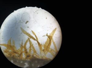
Juvenile Sugar Kelp in Seaweed City’s nursery on Governor’s Island. Image: Seaweed City
When the kelp does grow successfully, the response is visible the moment they haul it up. “When we pull it up for harvest, it is just like teeming with life,” Mahmood said. “Mollusks, bivalves, all kinds of crustaceans and worms.” Once, while pulling the line, she felt what she believed was “a pretty large American eel” brush past the kelp.
For Eddins, the most immediate effect is biodiversity. “There is not a lot of vegetation in Newtown Creek,” he said. The kelp creates “a mini ecosystem” in a waterway otherwise surrounded by vertical walls of concrete and steel.
Seaweed does more than provide habitat. Seaweeds are “great at taking in nitrogen and phosphorus,” Mahmood said. These are the same nutrients that pour into Newtown Creek whenever it rains and combined sewers overflow, making it an ideal place to test how kelp absorbs nutrients.
Through photosynthesis, kelp also removes dissolved carbon dioxide and releases oxygen. Eddins sees this as a natural counterpart to the city’s mechanical aeration system. Removing carbon dioxide also creates pockets of reduced acidity around the kelp. “These zones help shell building species like mussels and juvenile oysters that struggle in acidic conditions,” Eddins said.
The kelp takes up some contaminants as well. “It does take up some of the heavy metals, like arsenic, cadmium and copper,” Mahmood said, which she linked to the creek’s industrial history. “Probably because there was a copper smelting industry” nearby.
What they still cannot confirm is whether the kelp absorbs PCBs or PAHs, which is a group of long-lasting industrial chemicals once used in electrical equipment. “Every time I reach out about it, they just… don’t have the technology,” she said of the specialized labs she contacted. Because of that uncertainty, the kelp grown in Newtown Creek is not used as fertilizer. “We dry it and hold onto it,” Mahmood said, sometimes disposing of it through safer channels, while kelp grown on Governors Island is chopped and used as a soil amendment.
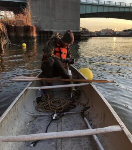
Luke Eddins out on a boat preparing to line the kelp. Image: Seaweed City
Projects like Seaweed City are part of a much larger, moving story about a waterway that State Assembly Member Emily Gallagher describes as “one of the most polluted places in the country.”
Newtown Creek was added to the federal Superfund National Priorities List in 2010, a designation for the nation’s most contaminated sites and meant to trigger a long term, federally overseen cleanup of toxic sediment. But more than a decade later, major in water remediation has yet to begin.
For over a century, factories along the creek dumped oil, heavy metals, chemicals and industrial waste directly into the sediment. That legacy remains. Layered onto it is the ongoing reality of New York’s combined sewer system, where stormwater and wastewater share the same pipe. “At a certain point, the pipe becomes over capacity,” Gallagher said. “It backs up and raw sewage starts flowing into the creek and around the neighborhood.” After major storms, she has seen standing sewage on streets and heard from residents whose ground floor apartments were inundated by wastewater rising through tubs and toilets.
The scale of contamination is visible to local community organizations.
Gus Perry, restoration associate at Newtown Creek Alliance, helps run water sampling from May to October. “We are testing for fecal bacteria to see how contaminated that water might be,” he said. Health guidelines suggest that if readings exceed around thirty bacteria per one hundred milliliters, a beach should close.
“On most days, we are getting into thousands,” Perry said. In roughly a quarter of their samples last season, the readings hit the upper limit of what their equipment could measure. After rainfall, he added, “it would be closed probably ninety five percent of the year if it was a beach.”
Newtown Creek Alliance formed in the early 2000s, dedicating itself to restoring and revitalizing Newtown Creek. It is led by Greenpoint residents angry about the refinery pollution beneath their neighborhood and the lack of attention to the creek. The group has a small staff of “about six people” said Perry, and they do a lot of work.
They grow native plants in a local nursery and replant them at sites where roads reach the water. They have installed floating and fixed salt marsh platforms and planted about 3500 plugs of Spartina alterniflora, a saltmarsh cordgrass, in a cove called Dutch Kills, restoring the lost salt marshes that used to cover thousands of acers of the creek.
Newtown Creek Alliance replanting a plot of marsh. Image: Newtown Creek Alliance
They also work on shellfish restoration with partners like Billion Oyster Project, installing structures that help oysters and mussels settle. The animals are unsafe to eat but provide filtration and habitat. “Seaweed City’s kelp lines, add another layer to that effort,” Perry said.
Further out in the harbor, Rob Buchanan has been tracking sewage pollution for more than a decade. As coordinator of the New York City Water Trail Association’s steering committee, he oversees a volunteer water quality program that samples sites across the city. Their tests focus on Enterococcus, a federal indicator for whether water is safe for swimming. “We use the same test the city uses at the bathing beaches,” he said. Results are color coded. Green meets swimming standards. Yellow means caution. Red means too polluted. “Newtown Creek is overwhelmingly red,” Buchanan said.
“It has not improved,” he added. Over 13 seasons of data, “if there is a trend, it is not yet discernible.” Rainy years spike the readings. Drier years flatten them. He contrasts the creek with the Gowanus Canal, where dredging and shoreline reconstruction have already begun. Newtown Creek remains in a long study and planning phase.
Buchanan believes the city could do more right now. “The combined sewer system cannot be rebuilt entirely,” he said. Most of New York is covered by roofs, pavement, and streets, and all that runoff flows into the same pipes as household wastewater.
“The only workable way to reduce overflows is by preventing rain from entering the pipes in the first place.” That means more trees, rain gardens, permeable pavement, and green roofs. It also means taking away parking spaces. “Cars are king,” he said.
He would also like real-time public notification of sewage discharges. Right now, the city issues model-based warnings, not direct measurements. “Notification does not solve the problem directly,” he said, but if people could see how much sewage entered their waterways each time it rained, there would be more pressure to fix it.
For Gallagher, the politics of Newtown Creek are inseparable from its history. Her district covers Williamsburg and Greenpoint, areas shaped by refineries, depots, and industrial plants on the creek. The neighborhood is home to the Greenpoint oil spill, often described as one of the largest oil spills on land in the United States, caused by decades of petroleum leaking beneath homes.
“One of the biggest issues in our district is environmental justice,” she said. Her work includes pushing for cleanup, air quality enforcement, new standards, and flood protections.
“Heavy rain can overwhelm combined sewers, causing raw sewage to overflow into the creek and even back up into homes,” she said. Replacing the system entirely would cost billions, so she is pushing for more projects like Gateway to Greenpoint, a former parking lot being rebuilt with plantings and underground basins to absorb stormwater before it reaches the sewer.
“Gateway to Greenpoint is going to be an opportunity to really absorb, like a giant sponge, a lot of that wastewater so it is not overflowing into the sewer system,” she said. She wants similar projects across the city but knows they require new kinds of planning and funding.
She drafted a bill for a stormwater fee that would charge property owners for large impervious surfaces and reward them for making land more absorbent. The bill has not yet passed. “We have to get really courageous about passing legislation,” she said.
Flooding, sewage, and rising insurance costs will only get worse as storms intensify.
The debate over what should happen next on Newtown Creek plays out in public meetings. Scientists, Newtown Creek Alliance staff, members of the North Brooklyn Community Boathouse, and officials from the Environmental Protection Agency and National Grid gathered at LaGuardia Community College recently. EPA staff walked through timelines, explaining what projects are planned on the site, the current clean-up efforts, how long it takes to design a remedy for contamination buried in sediment. Community members pushed for clearer health information, faster interim steps, and more ambitious restoration.
Back on the water, the work continues. Newtown Creek Alliance are partnering with Billion Oyster Project and tend salt marsh plantings at Dutch Kills, while Seaweed City monitors kelp growth and water conditions.
Despite everything, there are reasons to keep going. Perry talks about the birds he sees on the creek: gulls, cormorants, herons, egrets, and winter ducks. “Despite all of this nasty contamination,” he said, wildlife “is still making an effort to be present.”
Mahmood and Eddins are already thinking beyond one polluted inlet. They imagine seaweed gardens around the city, maintained like community gardens on land and supported by local residents and public funding, designed to make the water more habitable.
A creek recognized as one of the country’s most polluted urban waterways is still full of hidden life. If kelp can grow here, and if people are willing to climb fences, count bacteria, and plant marsh grasses, how different could this creek be in a generation?